Eʼelyaaígíí:San Diego-Tijuana JPLLandsat.jpg

Size of this preview: 800 × 504 pixels. Other resolutions: 320 × 201 pixels | 640 × 403 pixels | 1,150 × 724 pixels.
''full resolution''ígíí yishʼį́ nisin (1,150 × 724 pixels - 174 KIIŁTSOHʼÍÍŁKÉ, MIME type: image/jpeg)
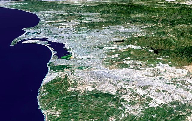
| Description | 3-D perspective image of the San Diego-Tijuana area from NASA's Shuttle Radar Topography Mission (SRTM) | |||||
| Date | ||||||
| Source | http://photojournal.jpl.nasa.gov/catalog/PIA03330 | |||||
| Author |
NASA/JPL/NIMA
|
|||||
| Permission (Reusing this file) |
|


łahgo ádaalyaaígíí
Ńtʼę́ę́ʼígíí yíníʼį́įgo biniiyé, naʼalkid/yoołkáłígíí bikáaʼgi "click" ádíílííł
| naʼalkid/yoołkáłígíí | thumbnailígíí | naaniigo/náásee | Choyoołʼįįhí | haneʼ | |
|---|---|---|---|---|---|
| kʼadígíí | 08:59, 4 Tʼą́ą́chil 2011 | | 1,150 × 724 (174 KIIŁTSOHʼÍÍŁKÉ) | 08OceanBeach SD | auto contrast |
| 07:28, 30 Tʼą́ą́tsoh 2007 |  | 1,150 × 724 (162 KIIŁTSOHʼÍÍŁKÉ) | Zzyzx11 | {{Information |Description=3-D perspective image of the San Diego-Tijuana area from NASA's Shuttle Radar Topography Mission (SRTM) |Source=http://photojournal.jpl.nasa.gov/catalog/PIA03330 |Date=February 2000 |Author=NASA/JPL/NIMA<br>{{SpaceShuttle}} |Per |
''Wikiibíídiiya'' bikáaʼgi choolʼį́/yitʼį́
ałʼąą dineʼé bizaadjí
- ar.wikipedia.org bikáaʼgi
- ban.wikipedia.org bikáaʼgi
- bn.wikipedia.org bikáaʼgi
- en.wikipedia.org bikáaʼgi
- fr.wikipedia.org bikáaʼgi
- he.wikipedia.org bikáaʼgi
- hu.wikipedia.org bikáaʼgi
- id.wikipedia.org bikáaʼgi
- jv.wikipedia.org bikáaʼgi
- pt.wikipedia.org bikáaʼgi
- ro.wikipedia.org bikáaʼgi
- te.wikipedia.org bikáaʼgi
- tr.wikipedia.org bikáaʼgi
- vi.wikipedia.org bikáaʼgi
- zh.wikipedia.org bikáaʼgi