Eʼelyaaígíí:Cambodia indochina map 1886.jpg
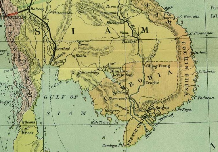
Cambodia_indochina_map_1886.jpg (758 × 529 pixels - 197 KIIŁTSOHʼÍÍŁKÉ, MIME type: image/jpeg)
łahgo ádaalyaaígíí
Ńtʼę́ę́ʼígíí yíníʼį́įgo biniiyé, naʼalkid/yoołkáłígíí bikáaʼgi "click" ádíílííł
| naʼalkid/yoołkáłígíí | thumbnailígíí | naaniigo/náásee | Choyoołʼįįhí | haneʼ | |
|---|---|---|---|---|---|
| kʼadígíí | 02:59, 2 Tʼą́ą́tsoh 2008 |  | 758 × 529 (197 KIIŁTSOHʼÍÍŁKÉ) | Calliopejen1 | {{Information |Description=Detail showing Cambodia from map of French Indochina |Source=Crop of Image:Indochina_map_1886.jpg |Date=1886 |Author=Scottish Geographical Magazine |Permission={{PD-old}} |other_versions= }} [[Category:Maps of the history o |
''Wikiibíídiiya'' bikáaʼgi choolʼį́/yitʼį́
(eʼelyaaígíí doo choolʼį́į da)
ałʼąą dineʼé bizaadjí
- arz.wikipedia.org bikáaʼgi
- bat-smg.wikipedia.org bikáaʼgi
- be-tarask.wikipedia.org bikáaʼgi
- beta.wikiversity.org bikáaʼgi
- bxr.wikipedia.org bikáaʼgi
- cv.wikipedia.org bikáaʼgi
- da.wikisource.org bikáaʼgi
- de.wikipedia.org bikáaʼgi
- de.wikisource.org bikáaʼgi
- de.wikiversity.org bikáaʼgi
- en.wikipedia.org bikáaʼgi
- en.wikisource.org bikáaʼgi
- en.wikivoyage.org bikáaʼgi
- eo.wikipedia.org bikáaʼgi
- es.wikibooks.org bikáaʼgi
- es.wikinews.org bikáaʼgi
- es.wikisource.org bikáaʼgi
- fiu-vro.wikipedia.org bikáaʼgi
- fi.wiktionary.org bikáaʼgi
- frr.wikipedia.org bikáaʼgi
- fr.wikipedia.org bikáaʼgi
- fr.wikibooks.org bikáaʼgi
- fr.wikinews.org bikáaʼgi
- fr.wikiquote.org bikáaʼgi
- fr.wikisource.org bikáaʼgi
- fr.wikiversity.org bikáaʼgi
- fr.wiktionary.org bikáaʼgi
- fy.wikipedia.org bikáaʼgi
- gu.wikipedia.org bikáaʼgi
- gv.wikipedia.org bikáaʼgi
- haw.wikipedia.org bikáaʼgi
- hsb.wikipedia.org bikáaʼgi
- hy.wikipedia.org bikáaʼgi
- ia.wikipedia.org bikáaʼgi
- ie.wikipedia.org bikáaʼgi
- ig.wikipedia.org bikáaʼgi
- incubator.wikimedia.org bikáaʼgi
- io.wikipedia.org bikáaʼgi
- is.wikipedia.org bikáaʼgi
- it.wikipedia.org bikáaʼgi
- it.wikinews.org bikáaʼgi
- it.wikisource.org bikáaʼgi
- ja.wikipedia.org bikáaʼgi
- ja.wiktionary.org bikáaʼgi
- ka.wikipedia.org bikáaʼgi
- kk.wikipedia.org bikáaʼgi
- kl.wikipedia.org bikáaʼgi
View more global usage of this file.
