Eʼelyaaígíí:Bonadelle Ranchos-Madera Ranchos, California (20952163403).jpg

''full resolution''ígíí yishʼį́ nisin (4,000 × 3,000 pixels - 2.62 TÁÁŁTSOHʼÍÍŁKÉ, MIME type: image/jpeg)
.jpg)
Summary
| Description |
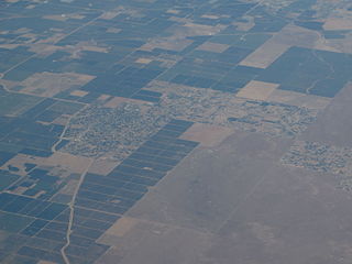
Bonadelle Ranchos-Madera Ranchos is a census-designated place (CDP) in Madera County, California, United States. It is part of the Madera–Chowchilla Metropolitan Statistical Area. The population was 8,569 at the 2010 census, up from 7,300 at the 2000 census. The Bonadelle Ranchos is often regarded as a Valley-Foothill transitional zone, because its elevation is higher than average for valley but slightly too low to be considered part of the Sierra foothills. Immediately Northeast lies the rugged foothills of the Sierra Nevada range. Its environment corresponds, showing qualities of a transition zone. The Northeast portion of the area is the highest in elevation,and small tabletop hills are present: most notably Adobe Hill, which lies at an elevation of 640 feet. All throughout the area, there is large, rolling hills. Multiple creeks run through the area, but none are large enough to bring constant flow. The creeks include Little Dry Creek, Bonadelle Creek, Cottonwood Creek, and Root Creek. Many of these waterways flow in the winter months, when rainfall and snow filter down from the nearby foothills. There are many seasonal ponds in the area, however most are too small and short-lived to offer recreational activities. Many of the wildlife is typical for this type of environment. Mammals include foxes, ground squirrels, coyotes, raccoons, skunks and occasionally bobcats and mountain lions. Dove, crows, ravens, ducks, Scrub jays, California woodpeckers, egrets, red tailed hawks, turkey vultures, and geese can be found as well. en.wikipedia.org/wiki/Bonadelle_Ranchos-Madera_Ranchos,_C... en.wikipedia.org/wiki/Wikipedia:Text_of_Creative_Commons_... |
| Date | |
| Source | Bonadelle Ranchos-Madera Ranchos, California |
| Author | Ken Lund from Reno, Nevada, USA |
| Camera location | | View this and other nearby images on: OpenStreetMap |
|---|
.jpg¶ms=037.041013_N_-119.595634_E_globe:Earth_type:camera_source:Flickr_&language=nv)
Licensing
- You are free:
- to share – to copy, distribute and transmit the work
- to remix – to adapt the work
- Under the following conditions:
- attribution – You must give appropriate credit, provide a link to the license, and indicate if changes were made. You may do so in any reasonable manner, but not in any way that suggests the licensor endorses you or your use.
- share alike – If you remix, transform, or build upon the material, you must distribute your contributions under the same or compatible license as the original.
| This image was originally posted to Flickr by Ken Lund at https://flickr.com/photos/75683070@N00/20952163403. It was reviewed on 4 Níłchʼitsoh 2015 by FlickreviewR and was confirmed to be licensed under the terms of the cc-by-sa-2.0. |
łahgo ádaalyaaígíí
Ńtʼę́ę́ʼígíí yíníʼį́įgo biniiyé, naʼalkid/yoołkáłígíí bikáaʼgi "click" ádíílííł
| naʼalkid/yoołkáłígíí | thumbnailígíí | naaniigo/náásee | Choyoołʼįįhí | haneʼ | |
|---|---|---|---|---|---|
| kʼadígíí | 04:50, 4 Níłchʼitsoh 2015 | | 4,000 × 3,000 (2.62 TÁÁŁTSOHʼÍÍŁKÉ) | INeverCry | Transferred from Flickr via Flickr2Commons |
''Wikiibíídiiya'' bikáaʼgi choolʼį́/yitʼį́
ałʼąą dineʼé bizaadjí
- en.wikipedia.org bikáaʼgi
- pl.wikipedia.org bikáaʼgi
- simple.wikipedia.org bikáaʼgi
- sr.wikipedia.org bikáaʼgi
- uk.wikipedia.org bikáaʼgi